
Published by: Nuru
Published date: 09 Dec 2021
In this chapter, we discuss about the Zones and Districts of Nepal. Grade 8 Social Studies, Reference Notes.
Nepal is a landlocked Himalayan country bordered by China to the north and India to the south, east and west. It has an area of 1,47,181 sq.km which is only 0.3% of the total landmass of Asia and 0.03% of the world. Despite its vast resources, Nepal has remained a backward country for years. Among several causes, one is the country’s difficult physical structure. Nepal, though small, is one of the few countries of the world with most varied land topography.
Based on its landform and climate, Nepal is divided into three regions: the Himalayan Region, the Hilly Region and the Terai Region. These are distinct ecological regions running west-east horizontally. The high mountains in the north, the moderate Mahabharat hills in the centre and undulating chure hills with their sheltered lowland in the south are the predominant landscapes of the country.
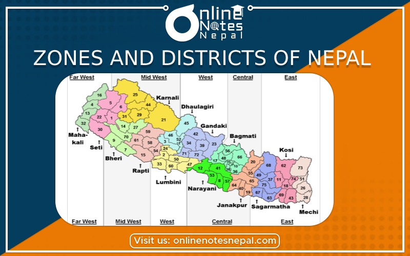
As we know government alone cannot take care of the whole country, so to carry out uniform development to increase people's participation, to use resources, to decentralize the power our country is divided into 5 development regions, 14 zones and 75 districts. Such regions are known as Administrative Regions. Each district is headed by a chief district officer (CDO) and is responsible for maintaining law and order and coordinating the work of field agencies of the various government ministries.
The division of districts of Nepal according to the zones is shown in the following table:
| Development Region | Zones | Districts |
| Eastern Development Region | Mechi
Koshi Sagarmatha |
Taplejung, Panchthar, Ilam, Jhapa
Morang, Sunsari, Dhankuta, Terhathum, Bhojpur, Sankhuwasabha Saptari, Siraha, Udaypur, Khotang, Okhaldhunga, Solukhumbu |
| Central Development Region | Janakpur
Bagmati Narayani |
Mahottari, Dhanusha, Sarlahi, Sindhuli, Ramechhap, Dolakha
Kavre Palanchok, Kathmandu, Lalitpur, Bhaktapur, Sindhupalchok, Rasuwa, Dhading, Nuwakot Rautahat, Bara, Parsa, Chitwan, Makwanpur |
| Western Development Region | Gandaki
Dhaulagiri Lumbini |
Kaski, Tanahun, Lamjung, Gorkha, Syanjhya, Manang
Parbat, Myagdi, Baglung, Mustang Rupandehi, Nawalparasi, Kapilbastu, Arghakhanchi, Gulmi, Palpa |
| Mid-Western Development Region | Karnali
Rapti Bheri |
Dolpa, Jumla, Mugu, Humla, Kalikot
Dang, Salyan, Pyuthan, Rolpa, Rukum Banke, Bardiya, Surkhet, Dailekh, Jajarkot |
| Far-Western Development Region | Seti
Mahakali |
Kailali, Doti, Accham, Bajura, Bajhang
Kanchanpur, Dadeldhura, Baitadi, Darchula |