
Published by: Nuru
Published date: 20 Jan 2022
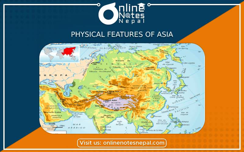
Asia is crossed by the equator in the south, by the Tropic of Cancer in the center, and the Arctic Circle in the north. Asia is the biggest continent. It is bounded by the Pacific Ocean in the east, the Arctic Ocean in the north, and the Indian Ocean in the south. In the west lies the continent of Europe.
The Ural Mountains divide it from Europe in the west; the Red Sea and Suez Canal cut it off from Africa, and the Bering Strait, 88 km from the sea, separates it from North America in the east. Asia occupies 1/3rd of the world's land area. But 2/3rd of the world population lives in Asia. It contains more than 40 countries and every type of climate.
Asian landform highly varies. The continent constitutes many high mountain ranges of the world, including the Himalayas, the highest of all. Mt.Everest, a peak in the Nepalese part of the Himalayas is the highest peak in the world. The Karakoram, Kunlun, and the Hindu Kush are other important ranges.
These high ranges run into different directions from the Pamir Knot, popularly known as 'the roof of the world' where the borders of India, Pakistan, Afghanistan, Tajikistan, and China converge. Iranian plateau, Tibetan plateau, and Deccan plateau in India are high-lying. The north of Asia is a great Siberian plain formed by acidic soil and mostly covered by ice. Extensive valleys and basins drained by the Hwang Ho, Irrawaddy, Ganges, Indus, Tigris, Euphrates, etc. have remained the areas of famous ancient civilizations. Coastal plains mainly in the east and south-east are fertile agricultural regions.
The physical features of Asia can be classified into the following:
a. The Northern region
The northern valleys continue from Ural mountain in the west to the Bering strait in the northwest. This area consists of the Great Siberian plain which has been created by the rivers Ob, the Yenisey, and Lena. The rivers run near the northern side toward the Arctic ocean.
b. The Central mountains and plateaus
The Himalayas mountains extend from the Indian subcontinent to the rest of Asia. It is situated to the south of the northern lowlands. The Karakoram, the Elbruz, the Sulaiman, the Kunlun and TieaShan, and the Himalayas are the major important mountains of Asia. The Himalayas are so vast that they are composed of three different mountain belts. On the other hand, there are many plateaus. The plateau is not uniformly flat but contains some high mountains and low river basins. The Tibetan plateau is the largest plateau of Asia which is also known as the "Rooftop of the world".
c. The Southern Plateaus
These plateaus lie in the southern part of Asia. It is made up of old hard rocks. The Deccan plateau is a large plateau in the southern part of Asia. The Plateau of Arabia and the plateau of Yunnan are the significant plateaus of this region.
d. The Great River valleys
The first great civilizations all grew up in river valleys. These valleys are situated between the central mountain ranges and the southern plateaus. Some major rivers of this region are Tigris, Euphrates, Hwang Ho, Mesopotamian, Indus, Yangtze, Brahmaputra, Menam, and the Ganges.
e. The Island chains
The island chains extend in the east and southeast of the mainland of Asia. Where a chain of an island is found. The group of islands is synonymously known as the Archipelago of Asia. Some major island of this is Japan, the Philippines, Java, Sumatra, etc.
Asia is a very large landmass extending from the equatorial to the Polar Regions. This makes it possible for the continent to have all kinds of climates of the world. The peninsulas and islands in the south and in the southeast of the continent have a tropical wet climate.
South Asia along with eastern china and neighboring areas, has a tropical monsoon climate while the southwestern part of the continent, often known as the Middle East, has a hot desert climate. Central Asia lies beyond the great mountains and far from the sea is a rain shadow area and has extreme climate conditions. The Gobi is a cold desert at its center. The far north has temperatures often below the freezing in winter.
Asia's natural vegetation greatly varies as per the diverse landform and climate conditions. Pine trees grow in very cold conditions of the month. Their leaves are rolled up to form needles and this prevents them from losing water. These conical-shaped coniferous forests are found extensively in the Siberian plain. The pine forest belt is known as taiga. There is a region of grassland called steppe in a band extending across China, Mongolia, Kazakhstan, and Russia, and extending further into Europe. Temperate forests have broad-leaved trees.
Tropical rain forest found in the areas near the equator is very thick with tall trees up to 30 m, some are much higher than other lower-level trees. There are many species, of animals, birds, and insects. The wood is hard and valuable. Many of the Asian forests are in danger from deforestation and there is very little vegetation in the hot deserts of the Arabian Peninsula.