Some Ongoing Projects of Nepal
Project
A project is a planned action set up to achieve balanced and proportionate economic growth and human development. Following are some of the ongoing projects in Nepal
1. Mobile Phone Distribution project
Location: Throughout the country
Aims:
a. To distribute 43 lakhs mobile phones to the people of the country within 3 years.
b. To provide mobile phone services throughout the country.
Benefits:
After the completion of the project, all the 75 districts will have the facility of telecom service and among 100, 16 people will get the facility of the mobile phone.
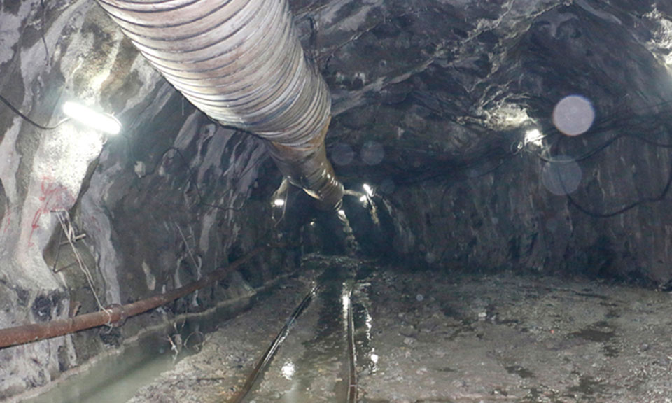
2. Melamchi Drinking Water Project
A project that will bring water from the Melamchi river of Sindhupalchowk situated north of Kathmandu by laying down the pipeline through a tunnel that will distribute drinking water in the Kathmandu valley.
 Objectives:
This project has been launched to fulfill the scarcity of water in Kathmandu valley.
Benefits:
After the completion of the project, the daily supply of water in the valley will be 17 crore liters and for a few years, this project will be able to fulfill the scarcity of water in the valley.
This project has been launched with the help of the Asian Development Bank (ADB), donor countries, and the Government of Nepal.
3. Solar Lamp (Tuki) distribution project
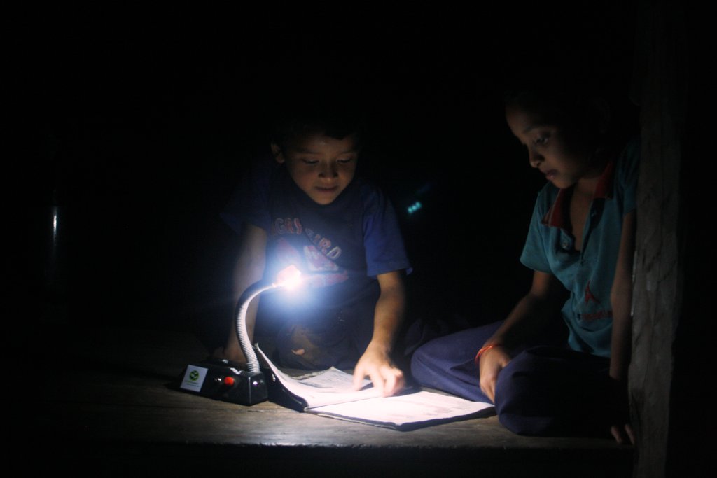
The government of Nepal has conducted a program "Karnali Ujyalo Karyakram" to provide solar lamps to the Karnali zone of Nepal which can light two bulbs through the solar energy to 60000 families of five districts of Karnali region. 95% of the investment is done by the government while 5% is to be done by the consumer themselves.
Objectives:
To provide solar light to the poor and needy people of the rural area.
Benefits:
- According to the program, each family will get the provision to light two electric bulbs and also can listen to a small radio.
- Students in remote areas can study in the evening.
- Means of communication like radio will bring awareness to the people regarding the political, social, and economical condition of the country as well as in personal hygiene and sanitation.
4. Secondary Education Support Program
Secondary Education Support Program has been conducted under the Ministry of Education and Sports throughout the country. The first phase of 15 years long project was conducted from 2003 to 2008 A.D. The project has been launched with the help of the Asian Development Bank, DANIDA, and the government of Nepal.
Objectives:
a. To increase school enrollment.
b. To make a curriculum for quality education.
c. To make easy availability of textbooks.
d. To provide different training materials and physical facilities.
Human Development Index and Nepal
Below is a conversation between a teacher and student on the lesson on the Human Development Index (HDI).
Student: What is HDI, miss?
Teacher: Before understanding HDI, we need to know more about Human Development. The development of human health, education, food, housing, skill, etc is overall human development. The index showing the levels of economic, social, educational development of any country is the HDI. This helps to strengthen the alternatives that help a human, society, and country in itself. Three factors responsible for human development are per capita income, education, and average age. HDI for any geographical area, people, society, etc can be calculated by taking these three factors into account. HDI is calculated in the range of 0 to 1.
Student: Why is HDI important?
Teacher: HDI is important because:
- To know the level of Human Development in any area.
- To know the areas that need improvement in human development.
- Improve the human development situation.
- To make the plans for improvement of human development in any country.
Student: How do we calculate HDI?
Teacher: We need the Average Age Index, Education Index, and Per Capita Income Index. The following formulas are updated after 2010 A.D.
- Average Age Index
Average Age = (Average Age for the subjected country - Minimum Average Age for the World) / (Maximum Average Age for the World - Minimum Average Age for the World)
- Education Index
Education Index = ((Average Educational Involvement Time for the subjected country) / 15) + (Expected Educational Involvement Time for the subjected country) / 18)) / 2
- Income Index
Income Index = ((Average Per Capita Income for the subjected country) - (Minimum Per Capita Income for the World)) / ((Maximum Per Capita Income for the World) - (Minimum Per Capita Income for the World))
- HDI
HDI = √(Average Age Index x Education Index x Per Capita Income Index)
Student: What is Nepal’s HDI?
Teacher: Nepal’s HDI is developing in comparison to the developed countries. Nepal was ranked 157th (HDI 0.463) in 2012 AD, 146th (HDI 0.543) in 2013 AD, and 145th (HDI 0.548) in 2015 AD.
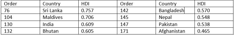
HDI for SAARC countries, 2015
 HDI for the world, 2015
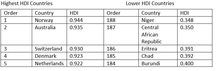
- Which are the countries with the highest HDI? What could be the reason for them to have the highest HDI?
- Evaluate the HDI situation for SAARC countries.
- What could be the challenges for countries with low HDI?
- What should be done to improve HDI?
Federal States of Nepal
The constitution of Nepal has divided Nepal into 7 federal states.
- State No. 1
This state covers the Himalayan, Hilly, and Terai regions of Eastern Nepal. The tallest peak in the world, Mt. Everest falls in this state, as does Mt. Kanchanjunga, Mt. Makalu, Mt. Cho Oyu, etc. Sagarmatha National Reserve, Makalu & Barun National Reserves also fall here. This state covers about 18% (25,905 sq. km) of Nepal’s total area. The census of 2068 puts the population of this state at approx. 45 lakhs. The ethnic groups of Rai, Limbu, Lepcha, Rajbansi, Koche, Meche, Bahun, Chhetri, Sherpa, etc reside in this state. Baraha Chhetri, Pathibhara, Halesi Mahadev, Chintang Devi, etc are the major religious destinations. The main food crops are Rice, Corn, and Wheat. The main cash crops are Jute, Tea, Cane, Tobacco, etc. Jute mills, sugar factories, cotton cloth factories, tea plantations, etc. are the industries that are the majority in this state. High agricultural areas, high contribution to the GDP from agricultural products, high literacy rate, etc are the main features of this state.
- State No. 2
This state hosts 8 districts in the Terai region, which extends from Parsa to Saptari. This state cover approx. 7% (9661 sq. km) area. Approx. 54 lakh people reside here, which is about 20% of the total population of Nepal. The main ethnic groups are Yadav, Tharu, Dalit, Muslim, etc. Every district in this state has a majority of people from the Madhesi community. East-West highway and Hulaki highway are the main roads that pass through this state. The majority of the industries in Nepal fall in this region, so it can be said that this is a rather developed state in terms of industries. Birgunj, Lahan, Rajbiraj, Hariwan, Chandranigahapur, Simara, Janakpur, etc are the main industrial cities in this state. Ramjanaki Temple, Chinnamasta Devi Temple, Gadhimai Temple, etc. are the main religious destinations here. Most of the business enters the country through the Birgung port. To the north of this state lies the Chure forest range. Most of the geography of this state is flat. Along with a high population and high per capita income, this state has the highest cultivable land to area ratio. The contribution of this state to the GDP is via agriculture, fish farming, and industries. Maithali, Bajjika, Bhojpuri, Nepali, etc. are some of the languages spoken in this state.
- State No. 3
Nepal’s capital city Kathmandu lies in this state, and most of the area is of Hilly and Himalayan topography. Ganesh, Langtang, Jugal, Gaurishankar, etc. are the mountain ranges in this state. As per area, this state covers 14% (20,300 sq. km) of the total area of Nepal. Census of 2068 BS puts the population of this state at 55lakhs, which is 21% of the total population of Nepal. Sherpa and Bhote ethnic communities are the majority in the Himalayan region. Newars have the majority in the Kathmandu Valley, while other districts have Kirel, Tamang, Magar, Tharu, etc. The main cities of this state are Kathmandu, Bhaktapur. Lalitpur, Banepa, Hetauda, Chitwan, Dhulikhel, etc. Gosaikunda, Pashupatinath, Syambhu, Budanilkantha, Baudhanath, Dolakha Bhimsen, Dakshinkali, Palanchowk Bhagwati, etc. are the main religious destinations. This state has the most number of youth citizens. There are various infrastructures like electricity, drinking water, education, roads, etc. more developed than other states. This state is leading in education, mining, and contribution to the GDP.
- State No. 4
Himalayan ranges Dhaulagiri, Annapurna, Manaslu, Himchuli, etc. fall in this region. Fewa, Rupa, Begnas, Tilicho Lakes are the main lakes in the region. Manang and Mustang are considered to be the natural and heavenly locations. Seti, Kaligandaki, Marsyangdi, etc. rivers irrigate the land in this state. This state covers 14% (21,504 sq. km) of the area and has a population of 24 lakhs according to the census of 2068 BS. Kaligandaki and Marsyangdi rivers have big hydroelectricity stations. Pokhara, Bandipur, Muktinath, Gorkha, and Manakamana are some of the tourist attractions. The main ethnic groups in this area are Magar, Bahun, Gurung, Chhetri, Thakali, Dura, etc. The religious destinations are Manakamana, Bindyabasini, Hrishikesh, Muktinath, Baglung Kalika, Galeshwor, etc. It has a sparse population to the land ratio. This state has a high literacy rate, high hydroelectricity potential, and high access to drinking water. It has snowfall covering many areas, and with less agriculture and less road access, the contribution to GDP is low.
- State No.5
This state has mostly terai and hilly areas and doesn’t have any Himalayan ranges. Rivers like Rapti, Tinau, Badigad, and lakes like Satyawati, Barkune, Jagdishpur can be found in this state. Big valleys like Dang, Deukhuri, Rampur, Madi, etc. lies in this state. It covers 15% (22,288 sq. km) of Nepal’s area and has a population of 49 lakhs according to the 2068 BS census. Jhimruk Hydroelectricity project is stationed in this state. The main business hubs in this state are Nepalgunj, Butwal, Bhairahawa, Krishnanagar, Tansen, Lamahi, Kohalpur, Rajapur, Bijuwar, etc. The religious and tourist attractions here are Lumbini, Ridi, Resunga, Swargadwari, Thakurdwara, Bageswori, etc. Rivers Sikta, Babai, Banganga, Tinau, etc. provide with irrigation projects that help the agricultural aspect of this state. Nepal Sanskrit and Lumbini Bouddha Universities lie here as well. Ethnic groups of Magar, Tharu, Bahun, Chhetri, etc. are main residents here, and the southern parts of the state have citizens of the Madhesi community in large numbers. There are many roadways and agricultural lands in the state.
- State No. 6
This Midwestern state covers the hilly and Himalayan region, so the environment is dry and cold. Kanjirowa and Patarasi mountains can be found here. Big and beautiful Rara and Phoksundo lakes fall under this state, and it covers approx. 20% (29,984 sq. km) of Nepal’s area. The population of this state is approx. 11.5lakhs according to the census of 2068 BS. The main business locations here are Birendranagar, Chhinchu, Dailekh, Salli Bazar, Jumla, etc. and herbs like Yarsagumba, Okhar, etc can be found here. Ratna, Karnali, and Chhinchu-Jajarkot are the main highways in the state. Religious destinations here are Deuti Bajyei, Chandan Nath, Shey Gumba, Kankre Bihar, etc. The ethnic groups of Thakuri, Chhetri, Bahun, Dalit, etc . are in the majority here. There are enough free grassy landscapes suitable for animal husbandry and herbs cultivation. Large areas and forests are the main features of this state, with Tila, Bheri, Sani Bheri, Humla Karnali, Mugu Karnali, etc. being the main rivers that flow through which have great electricity generating potential.
- State No. 7
This state lies in the far western part of the country. It hosts Shuklafanta Wildlife Reserve, Khaptad National Park, Mt. Api, Mt. Saipal, etc. It covers 13% (19,439 sq. km) of Nepal’s area and has a population of 25lakhs as per the 2068 BS. The development potential is carried by Tanakpur Barrage, Pancheswor Cooperative Project, West Seti Project, etc. BhimDatta Nagar, Dhangadi, Siligadi, Attariya, Tikapur, SanfeBagar, and Dadheldhura are the main business cities in the state. The main crops planted here are Rice, Wheat, Millet, Barley, Maize, etc. The citizens here are from Bahun, Chhetri, Tharu, Dalit, etc. ethnic groups. The main religious destinations are Ugratara, Shaileshwori, Badhimalika, etc. Most of the population in this state moves to India for employment opportunities. The main features of this state are a connection to roads in the terai region, easy access to India, and vast agricultural potential.