
Published by: Nuru
Published date: 25 Jan 2022
In this topic Physical Features of Nepal, we discuss the physical features, climatic division, riverine division, economic activities. Reference notes of 7.
Nepal is a small and beautiful country. It lies between two developed and big countries, India and China. It has south, east, and west borders with India and north with China. Due to the covering of these two countries, Nepal has become a landlocked country. The nearest sea from Nepal lies 1170 km far which is the Indian Ocean.
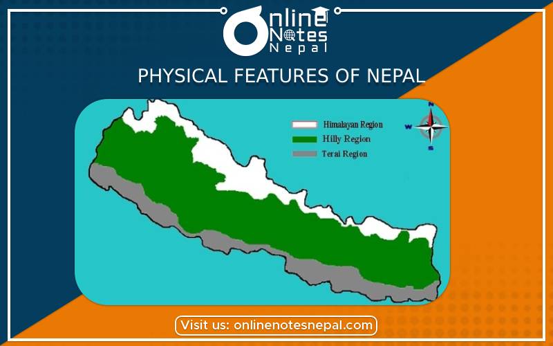
The total area of Nepal is 147,181 sq. km. It is divided into 3 divisions. The upper 15% part is a Himalayan region, the middle 68% part is the Hilly region, and the lower 17% part is the Terai region. All regions have different land topographies.
Physical Division of Nepal
The geography of Nepal can be divided into three physical regions from north to south.
Himalayan Region:
The Himalayan region lies in the northern part of Nepal. It covers an area of 22,081 sq. km making up about 15% of the total area of the country. It is a very cold region because we can find almost all mountains in this region. The highest peak of the world Mt. Everest and the deepest Arun valley of the world lies in this region. People of this region mainly follow Buddhism and Tibetan religions. Sherpas and Thakalis are the main inhabitants of this region. Potatoes, wheat, buckwheat are the main crops grown in this region. People wear thick clothes and drink milk of yak which consists of lots of fat.
Hilly Region:
The Hilly region lies between the Himalayan and Terai region. It covers an area of 100,080 sq. km making up about 68% of the country. It has neither hot nor cold but a moderate climate. The land in this region is not much fertile but still has some fertile land valleys in it, where agriculture is possible. Rai, Limbu, Magar, Tamang, Gurung, and Chepang including various other groups live in this region. People living in the Hilly region follow Hinduism along with other religions. Their main festivals are Dashain, Tihar, Lhosar, etc.
Terai Region:
Terai region lies in the southern part of Nepal. It covers an area of 25,020 sq. km making up about 17% of the total area of the country. It is called the ‘Granary of Nepal’ because it has plain, fertile land with alluvial soil and plenty of water for irrigation and agriculture. Due to heavy rain, we can find dense forests with tall trees. Brahmin, Kshetri, Tharu, Yadav, Jha including other Madhesi people live here. Hinduism and Islam are major religions of the Terai people. They celebrate Dashain, Tihar, Chhat, and Holi as major festivals. They wear thin cotton clothes called ‘Dhoti’.
Nepal is an agricultural country. Around 76% of people are engaged in agriculture and animal husbandry. Agriculture is the main source of income and base of people to adjust to the society as well as to the world. People living in town and city areas are involved in offices, tourism, industries, hospitals, and other modern sectors. The following table depicts the main economic activities of the people categorized under physical geography.
|
Geographical Region |
Economic Activities |
|
Himalayan Region |
Tourism, Animal husbandry, Trekking, Mountaineering, etc. |
|
Hilly Region |
Animal husbandry, Agriculture, Foreign Jobs, Businesses, Tourism, etc. |
|
Terai Region |
Agriculture, Animal husbandry, Pottery, Services, etc. |
Nepal is the second richest country in water resources because of having more than 6,000 rivers and rivulets including small and big rivers, ponds, and lakes. Almost all rivers flow from the Himalayan region by melting of the snows of the mountains and flow downward to hills, valleys, and plains based on drainage area. There are three principal riverine divisions from east to west:
The average temperature or weather of a certain place is called climate. All types of climatic conditions of the world can be found in Nepal. Varieties of flora and fauna are found in a small geographical area. Nepal's climate can be divided into three distinct zones, which are as follows:
Hot and Humid Climatic Zone:
This zone lies between 200 feet to 2000 feet above sea level. Terai, Chure range, and Inner Terai from east to west are the areas with this kind of climate. This region receives heavy rainfall throughout the year.
Temperate Climatic Zones:
This zone lies above 10,000 feet above sea level. The Hilly region of Nepal has these types of climatic zones. It has a moderate temperate climate which is neither hot nor cold.
Cold and Alpine Climatic Zone:
This zone lies above 10,000 feet above sea level. The Himalayan region of Nepal has this type of climatic zones. It receives snowfall and scanty rainfall in the winter season. It has a cold climate throughout the year.